Thanks CTD for basically admitting that there is no obstruction there to force the river to take this shape, by failing to provide any argument for an obstacle existing.
Got it? Now apply the meander-cutting abilities of even a small, small flood to this river. Wouldn't take much, would it? All that evotime, all 700,000 years, or 3 million, or 10 million, or whatever... To be sure, all that imagined time is not involved - only a percentage. I want to be clear about that. But we're still talking several tenthousands of years with the meanders failing to be cut by any floods.
Correct: at no time in all that past did the river flood over the banks and flow across the shortest route downhill.
The fact that this meander has not been cut into an oxbow does not mean that it is not a meander, just that it hasn't reached this final stage yet.
Instead the land began to rise before this occurred, and the river cut deeper and deeper as the land rose. When this uplift happens the conditions change for the way the river erodes. This slows down the side to side erosion as (a) the flow is more downstream (the energy gradient is sloped downstream) and (b) there is more bank to be eroded. According to the source this is called an
"incised meander" (yes, this occurs in other places in the world, shocking I know):
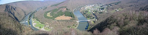
View of an incised meander in the Meuse in the French Ardennes
If the region later undergoes tectonic uplift, the meandering stream will again resume downward erosion. The meandering pattern will remain as a deep valley known as an incised meander (or entrenched meander). Rivers in the Colorado Plateau and streams in the Ozark Plateau are noted for these incised meanders. ...
Note that the meandering river does not normally erode down because it's path (energy gradient) is so flat, so it erodes the sides, but when the gradient is altered by the land rising then it resumes downward erosion. It's that energy gradient issue again.
And we have evidence of this uplift: the canyon now passes through a high point on a ridge, a place where it would have to flow uphill and along the side of a hill -- if it was cut through the current topography. The only explanation presented to date that explains this objective fact of reality is that uplift has occurred. In fact you have said you do not want to discuss this issue. Curious how it keeps coming back as evidence that uplift occurred.
Rather than any obstacle, the actual topography looks like the land was fairly level and gently sloping from left to right -- the very conditions for formation of meanders in the river noted in the link\source. If there was an obstacle then
where has it gone? Certainly it would not have eroded away it (a) it was an obstacle and (b) the top of the peninsula (where the obstacle to the flow would be) is still there.
Does that qualify as special pleading? Well you ain't seen nothin' yet. Actually, if you read RAZD's source, or even the bit he snipped, you've seen this, but it'd be easy to overlook. This is extra-special pleading because
No, because the logical fallacy of special pleading means that you apply different standards to evidence for and argument than you do for evidence against it, usually that your argument doesn't have to pass the same test as other evidence.
Special pleading fallacy - Accepting (or rejecting) an idea or criticism when applied to an opponent's argument but rejecting (accepting) it when applied to one's own argument.
The "
argument for" is that there was a meander in the river when the land began to rise, and this meander became embedded in the rock as it eroded down to it's current elevation. This can be tested by looking at the pictures to see if it looks like a meander (it has the characteristic sinuous double-back shape of mature meanders). This can be tested by seeing if there is evidence for uplift (the picture of the ridge shows uplift has occurred at some time in the past, modern measurements show that uplift is occurring now). This can be tested by seeing if this same pattern of erosion occurs in other places in the world (they are common enough that there is a term to describe them).
The "
argument against" is that there was some obstacle that forced the river to take this shape when the canyon began to form. This can be tested by looking at the pictures to see if there is any visible obstacle that would force the flow to go around rather than the most direct path downhill along the energy gradient (there is no visible obstacle) or evidence that it has been removed (the top of the peninsula is still flat, all rock layers in the area are horizontal and flat). This can also be tested by seeing if any known obstacle diversion erosion patterns match this meander pattern (no such evidence has been presented).
The same standard of objective evidence applies to both positions, therefore there is no speacial pleading. Saying that there is a logical fallacy in an argument doesn't make it so - you have to show the actual fallacy exists, and to claim there is a fallacy when none exists is a falsehood.
Even without a single flood in all those tenthousands of years, the river would still be able to cut through the narrow neck of land and straighten this meander, possibly leaving an "oxbow lake" or fossil "oxbow lake".
Thank you for agreeing that no flood has risen above the river banks and cut across the peninsula at any time since the land began to uplift. I also note that this has not occurred elsewhere in the canyon: there has been no significant straightening of the canyon by flood erosion.
Catch that Linear? That's twice RAZD's story differs from his own source.
Not only does the source go on to talk about incised meanders (so there is no contradiction) but it is a logical fallacy to claim that because something has not happened that it won't.
So what's next from our evocrew? More closed eyes? More pretending to be too stupid to understand? More pretending I haven't posted anything? Perhaps some ad homs against the wiki author? If you guys're so intent on repeating history, why not dig back into the past & try something that hasn't been done recently? You know, just to keep it interesting...
Nope, just more evidence that long term geology, standard river erosion and uplift provide all the explanations for what is seen in the Grand Canyon. Evidence that similar incised river erosion patterns exist in other places in the world that are also associated with uplift.
More noting that, in fact, CTD has
not posted any evidence that
any of the formations in the Grand Canyon are formed by flood flow, no evidence of an obstacle to water flow on top of the Horse Shoe peninsula, no evidence that flow around obstacles developes a sinuous meander pattern, no evidence that rivers flow uphill and along the sides of hills after the hill exists. More evidence that CTD still avoids the issues, such as the facts that none of the patterns in the Grand Canyon are characteristic of flood flow.
I don't need new arguments when the standard geological argument based on objective reality is sufficient. Nor do I need to indulge in
ad hominems if someone disagrees with me.
Enjoy.


